 Paikkatietohakemisto
Sea regions
Type of resources
Topics
Keywords
Contact for the resource
Provided by
Years
Formats
Representation types
Update frequencies
Service types
Scale
-
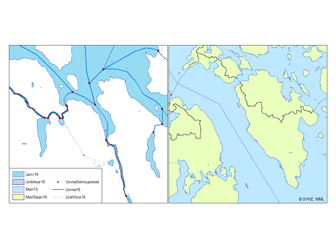
Ranta10 on topologisesti eheä Suomen vesistöjä kuvaava paikkatietoaineisto. Aineisto pohjautuu Maanmittauslaitoksen maastotietokannan vuosien 2000-2008 aineistoon (1:5 000-1:10 000). Maastotietokannan vesiin sisältyvistä kohteista mukaan on otettu alueina vakavedet sekä yli 5 m leveät virtavedet. Lisäksi mukana on maastotietokannan yli 200 m2:n kokoisia altaita. Viivoina kuvatuista alle 5 m leveistä virtavesistä on mukana vesistön päävirtausreitit sisältäen sekä 2-5 m että alle 2 m leveitä virtavesiä. Aineisto on uudelleen luokiteltu ja topologialtaan tarkistettu Sykessä. Aineiston pohjalta on Sykessä luotu uomia kuvaava uomaverkosto, jonka verkostomainen rakenne on tuotettu lisäämällä viivamaisiin jokiin aluemaisten jokien keskilinjat sekä järvien ylitykset ns. pseudouomilla. Aineistoon on lisätty myös järvi- ja uomatunnukset. Uomaverkosto kattaa kaikki vähintään yli 10 km2 yläpuolisen valuma-alueen omaavat uomat. Lisäksi uomaverkosto sisältää myös vesienhoidollisesti merkittäviä alle 10km2 yläpuolisen valuma-alueen omaavia uomia. Uomaverkosto ei sinällään kuvaa uuden vesilain vesistömääritelmän mukaista vesistöä. Uoma vaihtuu toiseksi yksilöllisen uomatunnuksen omaavaksi uomaksi aina uomaverkostoon kuuluvien uomien risteyksessä sekä uoman ja järven yhtymäkohdassa. Uomaverkosto on rakennettu siten, että kaikki siihen kuuluvat osat liittyvät topologiset yhteen ja omaavat oikean virtaussuunnan ja sitä voidaan käyttää erilaisiin verkostoanalyyseihin. Uomien välisiä topologia suhteita kuvaavat tiedot on tallennettu erillisiin tauluihin. Uomille on lisäksi laskettu muita paikantavia ja fysiograafisia tietoja. Uomaverkosto sekä koko Ranta10-aineisto kuuluvat Syken avoimiin aineistoihin (CC BY 4.0). Uomaverkosto-aineistosta on julkaistu INSPIRE-tietotuote. https://ckan.ymparisto.fi/dataset/uomaverkosto Koko Suomen kattava Ranta10-aineisto perustuu MML:n vuosien 2000-2008 maastotietokannan vaka- ja virtavesikohteisiin. Aineisto on päivitetty 16.11.2021 (lisätietoja historiatiedoissa). Käyttötarkoitus: Ranta10-aineisto ja siihen kuuluva uomaverkosto on luotu palvelemaan hyvin laajasti vesivarojen käyttöä ja hoitoa, vesiensuojelua ja vesientutkimusta sekä vesivaroihin liittyvää kansainvälistä ja kansallista raportointia ja tietojärjestelmätyötä. Lisätietoja: https://geoportal.ymparisto.fi/meta/julkinen/Dokumentit/ranta10.pdf Shoreline10 and River Network The Shoreline10 (Ranta10) is a topologically correct spatial dataset containing data on Finnish water bodies. The dataset is based on the topographic database of the National Land Survey of Finland in scale of 1:5 000-1:10 000 from years 2000-2008. The dataset contains lakes as well as most of human-made lakes over 200 m2 and more than 5 m wide rivers (polygons). Also included are the main flow paths of 2-5 m wide and less than 2 m wide streams (lines). The dataset has been reclassified and topologically corrected by Finnish Environment Institute (Syke). The continuous network has been created by combining rivers to the central lines through polygon rivers and lakes. The dataset includes also unique river codes and lake codes. The river network includes all river segments with catchment areas larger than 10 km². Other, smaller rivers with smaller catchment areas are included in case they are considered significant for water management tasks (e.g. WFD). Ranta10 does not represent the water bodies defined in the new water act. The change from one river segment to another, with unique river code and information, is located at the junction of the river network. The river code also changes at a connection point of a river segment and a lake. The river network has been created such a way that all parts of the network are linked topologically to each other and have a correct flow direction so that the dataset can be used for analyzing the network. Ranta10 including the river network is dataset owned by Syke and has same copyright and ownership conditions as other similar datasets owned by Syke. Syke applies Creative Commons By 4.0 International license for open datasets. Ranta10 dataset together with the river network were developed to serve wide variety of tasks related to water management, scientific research, water conservation and national and international reporting as well as associated information management. Data was updated 16.11.2021 (additional info. below in “historiatiedot”).
-
National Land Survey's Topographic map in vector format is a dataset depicting the terrain of all of Finland. The most important elements are the road network, administrative borders, preservation areas, population centres, geographic names, waterways, land use and elevation. The largest scale level (1:100,000) of the Topographic map in vector format is produced by generalising from the Topographic database. Topographic map 1:250,000 is produced by generalising the dataset 1:100,000. Topographic map 1:1,000,000 is produced by generalising the dataset 1:250,000. Topographic map 1:4,500,000 is produced by generalising the dataset 1:1,000,000. The geographic names have been generalised from the geographic names in the Geographic Names Register to map names suited to the scale in question. The administrative borders in the Municipal Division of each scale are used as administrative borders. The product belongs to the open data of the National Land Survey of Finland.
-
The Topographic map is a dataset depicting the terrain of all of Finland. The key elements in it are the road network, buildings and constructions, geographic names, waterways, land use and elevation. The more precise levels of the Topographic map consist of the same map objects and map symbols depicted in the same way as in the familiar Basic map. Basic map raster is applicable to be used, for instance, as a base map for planning land use or for excursion and outdoor recreational purposes in mobile devices and in various Internet services associated with nature. When going over to the more general datasets in the Topographic map, the number and visualisation of objects and map symbols changes. The generalised small-scale Topographic maps raster are applicable to be used as approach maps in e.g. mobile devices and Internet services. The product belongs to the open data of the National Land Survey of Finland.
-

Paikkatietohakemisto is a national metadata discovery service.